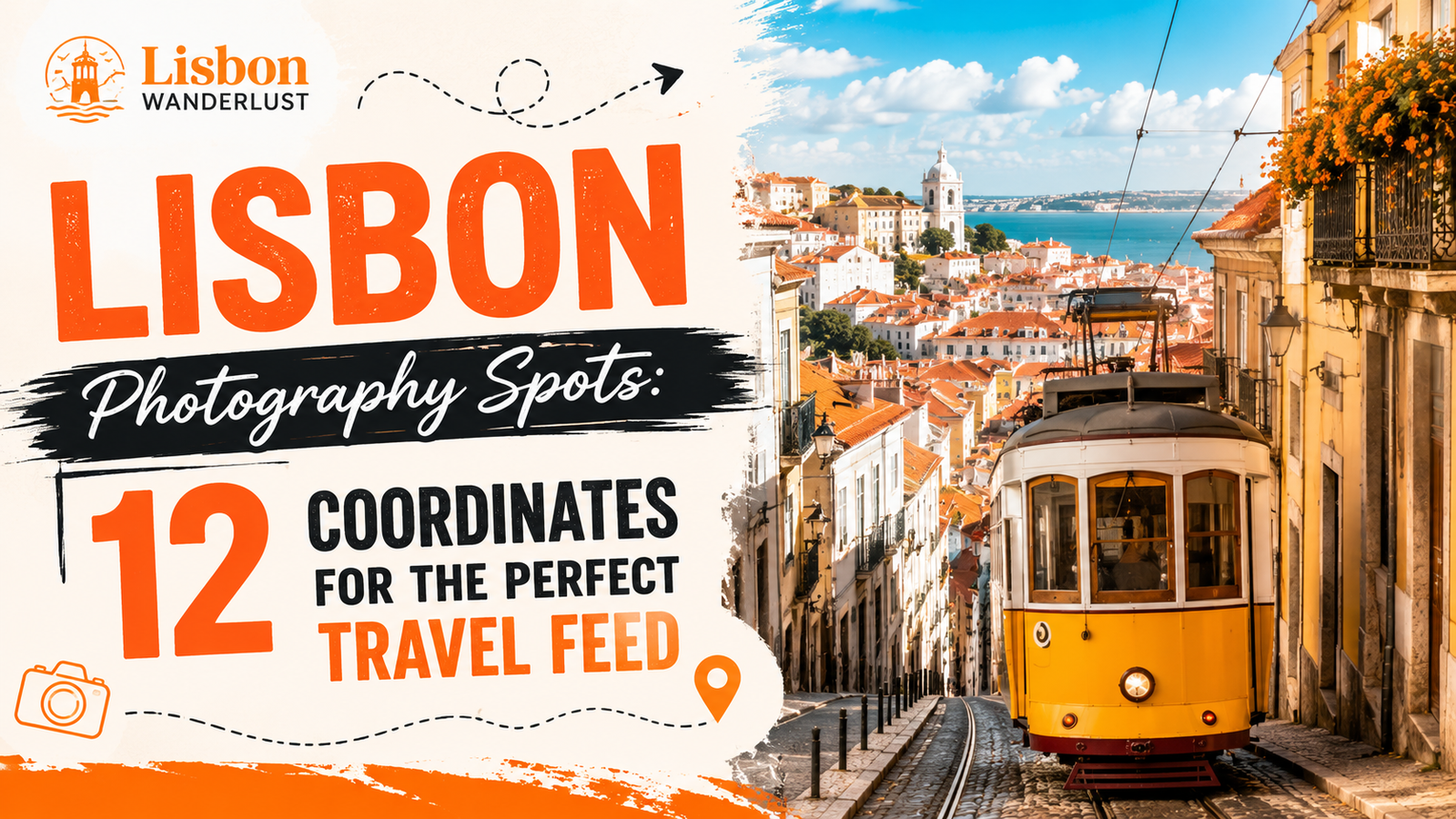
Lisbon Photography Spots: 12 Coordinates for the Perfect Travel Feed
Logistics, lighting conditions, and precise framing locations dictate the quality of architectural and travel images in Lisbon. Capturing clean, professional photographs across the city requires planning around cruise ship arrival schedules, steep topography, and the specific angles of daylight.
This guide provides exact navigational data, ticketing realities for 2026, and direct coordinates to ensure efficient transit between the city’s primary visual landmarks.
| Location Name | Best Lighting Time | Nearest Transport Stop | Primary Photo Subject |
|---|---|---|---|
| Miradouro das Portas do Sol | Sunrise | Largo das Portas do Sol (Tram 28E) | Alfama rooftops & Tagus River |
| Rua da Bica de Duarte Belo | 08:00 – 09:30 | Calhariz – Bica (Tram 28E / Ascensor) | Bica Funicular & river frame |
| Belem Tower | Golden Hour / Low Tide | Pedrouços (Tram 15E) | Manueline stone fortress |
| Miradouro da Senhora do Monte | Sunset | Rua da Graça (Tram 28E) | Panoramic cityscape & Castle |
| Praça do Comércio | 07:00 – 08:30 | Terreiro do Paço (Metro Blue Line) | Symmetrical arches & yellow facades |
| Livraria Bertrand | 09:00 (Opening) | Baixa-Chiado (Metro Blue/Green) | Tiled interior book vaults |
| MAAT Roof & Walkway | Afternoon / Golden Hour | Altinho (Tram 15E) | Modern curves & 25 de Abril Bridge |
| Pink Street | 07:30 – 08:30 | Cais do Sodré (Metro Green Line) | Pink pavement & overhead bridge |
| Santa Justa Lift | Blue Hour | Baixa-Chiado (Metro Blue/Green) | Industrial neogothic ironwork |
| Miradouro de Santa Luzia | Sunrise / Morning | Largo de Santa Luzia (Tram 28E) | Bougainvillea pergola & azulejos |
| Padrão dos Descobrimentos | Late Afternoon | Centro Cultural de Belém (Tram 15E) | Monolithic stone monument silhouette |
| Carmo Convent Ruins | 10:00 – 11:30 | Baixa-Chiado (Metro Blue/Green) | Open-air Gothic arches & sky |
1. Miradouro das Portas do Sol
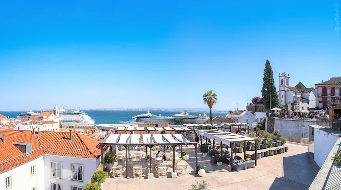
Exact Coordinates / Location
- Latitude/Longitude: $38.7122^\circ\text{ N}, 9.1305^\circ\text{ W}$
- Address: Largo das Portas do Sol, 1100-411 Lisboa
The Best Angle
Stand directly against the white stone balcony railing positioned on the main terrace, facing southeast. Aim the camera lens slightly downward to frame the cascading, terracotta-tiled roofs of the Alfama district. Ensure the twin white towers of the Church of São Vicente de Fora occupy the upper left third of the frame. This composition utilizes the natural leading lines of the descending alleyways toward the Tagus River.
Logistics & Transport
Take the historic Tram 28E or bus 737 directly to the “Largo das Portas do Sol” stop. Photographers starting from the downtown Baixa district can walk uphill via Rua de Augusto Rosa, which requires roughly 12 minutes of continuous ascending travel. A standard onboard cash fare for the tram costs €3.10, whereas using a pre-loaded Navegante card reduces the single transit cost to €1.80.
Know-Before-You-Go Tip
Sunrise is the only viable window to photograph this location without crowds blocking the balcony railing. The sun rises directly over the Tagus River, illuminating the pastel pink and yellow facades of Alfama with clean, direct front-lighting. Arrive exactly 20 minutes before scheduled sunrise to capture the pre-dawn blue hour ambient light.
2. Rua da Bica de Duarte Belo
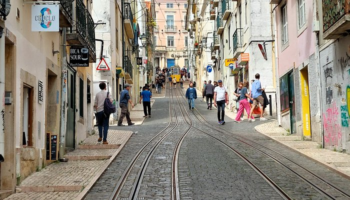
Exact Coordinates / Location
- Latitude/Longitude: $38.7101^\circ\text{ N}, 9.1465^\circ\text{ W}$
- Address: Rua da Bica de Duarte Belo, 1200-057 Lisboa
The Best Angle
Position the camera at the highest northern crest of the street, right at the intersection with Rua do Loreto. Shoot down the center of the steep tram tracks using a focal length between 50mm and 85mm to compress the perspective. Wait for the yellow Bica Funicular to reach the upper third of the hill. This framing aligns the historic yellow tram perfectly with the narrow street facades and the Tagus River background.
Logistics & Transport
Utilize the Metro Green Line and exit at the Baixa-Chiado station, then walk five minutes west along Praça Luís de Camões. Alternatively, ride Tram 28E to the “Calhariz – Bica” stop, which drops passengers at the exact top entry point of the photography zone. The funicular itself operates from early morning, but walking down the parallel pedestrian sidewalks is completely free.
Know-Before-You-Go Tip
The optimal window for clean lighting occurs between 08:00 and 09:30 when the sun clears the eastern buildings but before harsh shadows split the street in half. Delivery vans frequently block the tracks after 10:00, making early morning essential for an unobstructed view. Watch your footing carefully as the old cobblestones along this specific incline are highly polished and slippery.
3. Belem Tower (Torre de Belém)
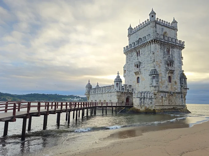
Exact Coordinates / Location
- Latitude/Longitude: $38.6916^\circ\text{ N}, 9.2160^\circ\text{ W}$
- Address: Av. Brasília, 1400-038 Lisboa
The Best Angle
Walk along the sandy coastal strip to the right (east) of the wooden gangway during a low-tide cycle. Position the camera close to the wet shoreline rocks to capture a reflective mirror effect of the fortress walls on the water surface. Frame the image horizontally with a wide-angle lens, positioning the tower on the left vertical grid line while letting the Tagus River fill the remaining space.
Logistics & Transport
Board Tram 15E from Praça do Comércio directly to the “Lg. Princesa” or “Pedrouços” stop, followed by an eight-minute flat walk through the park. Alternatively, utilize the regional train from Cais do Sodré station toward Cascais and disembark at the Belém station. Interior admission tickets cost €15 for adults, but photographing the exterior structure from the public beach zone requires no entry fee.
Know-Before-You-Go Tip
The monument operates from Tuesday through Sunday, meaning exterior spaces face fewer tour groups on standard Mondays. Golden hour provides optimal illumination as the setting sun strikes the western limestone face directly. Checking local maritime tide charts prior to arrival is necessary to guarantee the exposed sandbanks are accessible for low-angle reflections.
4. Miradouro da Senhora do Monte
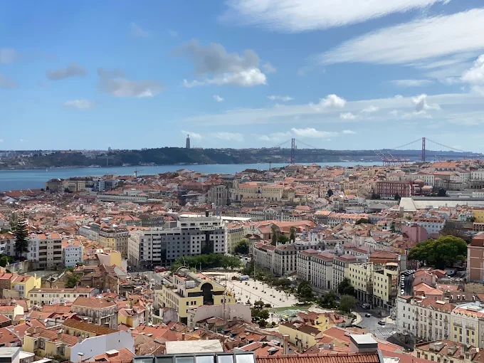
Exact Coordinates / Location
- Latitude/Longitude: $38.7191^\circ\text{ N}, 9.1326^\circ\text{ W}$
- Address: Largo do Monte, 1170-107 Lisboa
The Best Angle
Walk to the far southwestern edge of the viewing platform, just past the small chapel and the shade trees. Use a standard zoom lens ($24\text{mm} – 70\text{mm}$) to frame the panoramic view across the city center. Align the São Jorge Castle on the left side of the frame, allowing the 25 de Abril Bridge and the Tagus River to dominate the upper background. This composition captures the extreme height differences of the urban landscape.
Logistics & Transport
Ride the historic Tram 28E to the “Rua da Graça” stop, then walk uphill along Rua Damasceno Monteiro and Calçada do Monte. This walking route takes roughly seven minutes and covers a steep, continuous incline over traditional cobblestones. Tuk-tuks routinely transport passengers directly to the peak for variable fees ranging between €10 and €15 per ride.
Know-Before-You-Go Tip
This spot represents the highest natural viewpoint in the city, making it highly susceptible to high wind speeds that shake camera tripods. Sunset attracts hundreds of visitors daily, which requires arriving 45 minutes early to secure a clear position along the stone perimeter wall. The setting sun drops directly behind the hills opposite the platform, creating strong silhouettes across the downtown roofs.
5. Praça do Comércio (Arco da Rua Augusta)
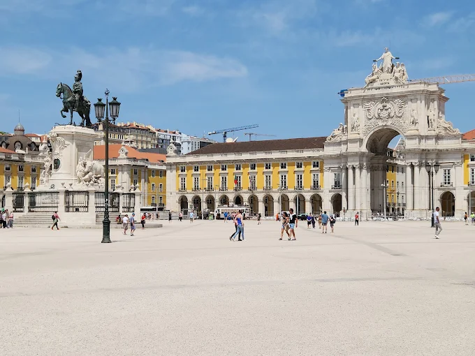
Exact Coordinates / Location
- Latitude/Longitude: $38.7075^\circ\text{ N}, 9.1364^\circ\text{ W}$
- Address: Praça do Comércio, 1100-148 Lisboa
The Best Angle
Stand inside the northern shaded corridor of the monumental stone arches along Rua Augusta, looking out south toward the open plaza. Use a wide-angle lens ($16\text{mm} – 24\text{mm}$) to utilize the massive geometric stone borders as a natural framing device. Center the statue of King José I precisely in the middle of the archway opening, ensuring the yellow symmetrical buildings extend evenly across both sides of the frame.
Logistics & Transport
Take the Metro Blue Line directly to the “Terreiro do Paço” station, which exits right into the eastern wing of the plaza. Multiple bus and tram lines, including Tram 15E and Bus 728, maintain major transit hubs directly along the waterfront border of the square. Accessing the open square is completely free to the public at all hours of the day.
Know-Before-You-Go Tip
The expansive plaza layout absorbs morning light cleanly between 07:00 and 08:30, creating long, crisp shadows with minimal foot traffic. Avoid photographing near midday, as the white ground stones reflect harsh, overexposed light that flattens architectural depth. Access to the top viewing platform of the Arco da Rua Augusta costs approximately €4.50, opening daily at 10:00.
6. Livraria Bertrand (Chiado)
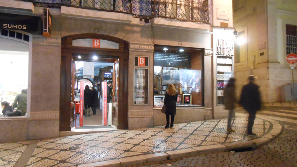
Exact Coordinates / Location
- Latitude/Longitude: $38.7111^\circ\text{ N}, 9.1424^\circ\text{ W}$
- Address: Rua Garrett 73-75, 1200-203 Lisboa
The Best Angle
Walk through the front retail rooms to the long central corridor lined with stone and brick vaults. Position the camera at the center line of the main arched walkway to emphasize the deep interior tunnel perspective. Shoot horizontally using a standard focal length ($35\text{mm} – 50\text{mm}$) to capture the rhythmic pattern of the vaulted ceilings alongside the warm wood shelves.
Logistics & Transport
Utilize the Metro Blue or Green Lines and exit at the “Baixa-Chiado” station, choosing the main Chiado exit. The storefront sits directly along Rua Garrett, less than a two-minute flat walk from the station exit doors. Entering the bookstore is free to the public, as it functions as a standard operating retail store rather than a formal museum.
Know-Before-You-Go Tip
This location holds the official Guinness World Record as the oldest operating bookstore in the world, causing heavy pedestrian traffic throughout the day. Arrive exactly at the 09:00 opening time to photograph the inner corridors before customers populate the walkways. Flash photography is prohibited inside the store, which requires utilizing a camera body with solid low-light ISO capabilities.
7. MAAT Roof and Walkway
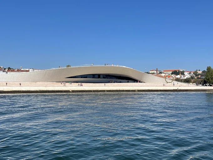
Exact Coordinates / Location
- Latitude/Longitude: $38.6961^\circ\text{ N}, 9.1927^\circ\text{ W}$
- Address: Av. Brasília, 1300-598 Lisboa
The Best Angle
Stand at the base of the eastern pedestrian ramp where the white, undulating roof structures meet the concrete riverfront walkway. Point the camera upward and westward using an ultra-wide lens ($14\text{mm} – 18\text{mm}$) to accentuate the sweeping, organic lines of the ceramic-tiled facade. Position the red towers of the 25 de Abril Bridge in the background to create a direct contrast between modern curves and industrial angles.
Logistics & Transport
Take the regional train from Cais do Sodré station and exit at the Belém station, followed by a flat five-minute walk east along the river pathway. Alternatively, board Tram 15E or Bus 728 and disembark at the “Altinho” stop. Access to the public roof walkway and exterior viewing platforms is free and open 24 hours a day, while interior gallery admission requires a separate ticket starting at €11.
Know-Before-You-Go Tip
Late afternoon and golden hour offer the most effective lighting conditions for this specific architecture. The low sun hits the 3D white ceramic tiles, reflecting ripples of light from the Tagus River directly onto the underside of the overhanging roof. Avoid visiting during mid-day rain, as the smooth, sloping roof surfaces can become slick and dangerous for foot traffic.
8. Pink Street (Rua Nova do Carvalho)
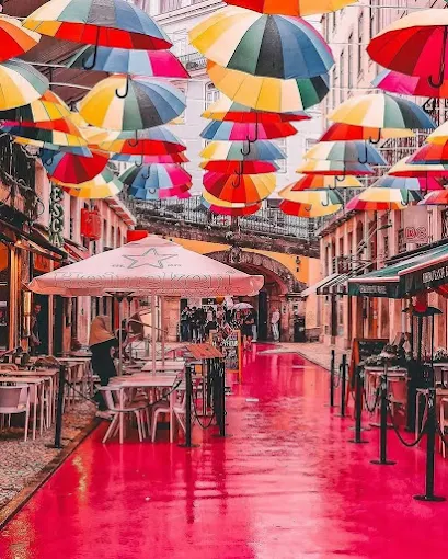
Exact Coordinates / Location
- Latitude/Longitude: $38.7073^\circ\text{ N}, 9.1434^\circ\text{ W}$
- Address: R. Nova do Carvalho, 1200-372 Lisboa
The Best Angle
Stand directly on the elevated stone stairs of the Rua do Alecrim bridge, which spans across the middle of Pink Street. Shoot down into the alleyway using a wide-angle lens to capture the bright pink pavement twisting between the buildings. Position the camera to include the colorful overhead umbrellas and the contrasting yellow facades of the lower bar entrances.
Logistics & Transport
Ride the Metro Green Line to the “Cais do Sodré” terminal station, then walk north for two minutes toward the riverfront blocks. Multiple major bus routes, including Bus 728 and 735, stop directly at the adjacent Cais do Sodré transit hub. Walking through and photographing the public street requires no entry fees or special permits.
Know-Before-You-Go Tip
This street serves as a central nightlife district, meaning trash, delivery trucks, and party debris litter the pavement until early morning cleaning crews pass through. The absolute best photography window occurs between 07:30 and 08:30 after the street is washed but before the nearby bars open for afternoon deliveries. The tall, tight buildings block direct sunlight during these hours, creating a soft, even shadow across the pink asphalt.
9. Santa Justa Lift
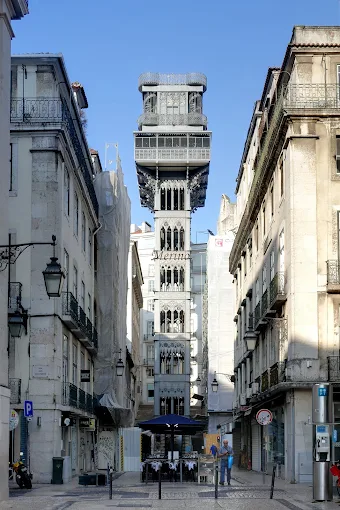
Exact Coordinates / Location
- Latitude/Longitude: $38.7121^\circ\text{ N}, 9.1394^\circ\text{ W}$
- Address: R. do Ouro, 1150-060 Lisboa
The Best Angle
Walk up to the elevated platform behind the Carmo Convent to access the top exit of the lift. Position the camera at the middle section of the iron walkway walkway connecting the main tower to the hill. Use a wide-angle lens to capture the grid pattern of the neogothic ironwork, framing the lower Baixa grid and the distant St. George’s Castle within the geometric gaps of the structure.
Logistics & Transport
To reach the upper viewpoint directly without waiting in elevator lines, walk to the “Baixa-Chiado” Metro station and exit via the Chiado side, then walk three minutes toward Largo do Carmo. To ride the lift upward from the bottom base, line up at the lower entrance on Rua do Ouro. A standard round-trip ticket costs €6.00, which is fully covered if utilizing a valid 24-hour Navegante transit card (€6.80).
Know-Before-You-Go Tip
The lower entrance lines routinely exceed an hour wait time during peak travel months. Arriving during the evening blue hour provides the cleanest lighting setup, as the industrial iron frame is artificial lit while the ambient sky retains a deep blue hue. The top viewing platform can experience overcrowding, so using a stabilizing monopod rather than a wide tripod helps maintain positioning along the narrow walkways.
10. Miradouro de Santa Luzia
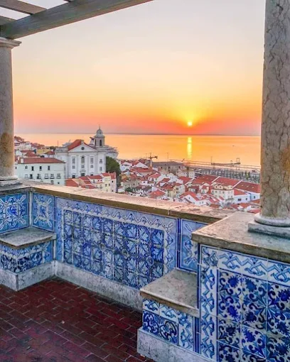
Exact Coordinates / Location
- Latitude/Longitude: $38.7116^\circ\text{ N}, 9.1305^\circ\text{ W}$
- Address: Largo de Santa Luzia, 1100-487 Lisboa
The Best Angle
Stand beneath the southern end of the white stone pergola structure, facing north toward the small garden beds. Frame the shot vertically using a wide-angle lens to capture the vibrant bougainvillea flowers draping down from the wooden overhead beams. Ensure the large panels of historic blue and white azulejo tiles on the back wall occupy the left third of your composition, creating a layered foreground that leads the eye toward the open sky.
Logistics & Transport
Board Tram 28E or take Bus 737 directly to the “Largo de Santa Luzia” transit stop. The viewpoint sits directly adjacent to the main street, making it accessible with zero steep stair climbing once you arrive at the terrace level. This public observation deck is fully open to the public 24 hours a day with no admission fees.
Know-Before-You-Go Tip
This terrace is highly popular with tour groups from mid-morning until late afternoon. Photographing at sunrise ensures completely empty walkways and soft, directional morning light that evenly illuminates the intricate tile work without casting harsh shadows from the overhead beams. During the spring and summer blooming seasons, the purple flowers provide an excellent color contrast against the white columns.
11. Padrão dos Descobrimentos
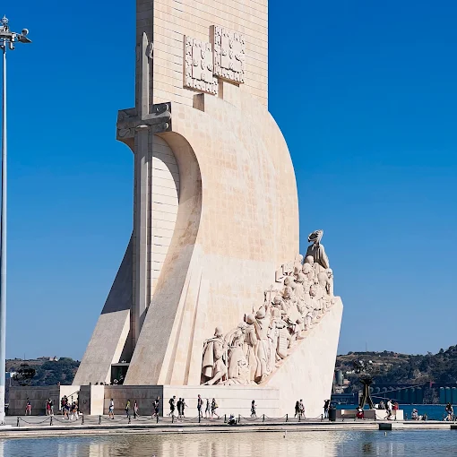
Exact Coordinates / Location
- Latitude/Longitude: $38.6936^\circ\text{ N}, 9.2057^\circ\text{ W}$
- Address: Av. Brasília, 1400-038 Lisboa
The Best Angle
Walk approximately 50 meters to the northwest of the monument along the concrete harbor line. Use a wide-angle lens ($24\text{mm}$) and position the camera low to the ground. Frame the massive concrete ship structure as a sharp silhouette against the sky, letting the geometric patterns of the limestone figures cut across the frame diagonally. This perspective emphasizes the scale of the historical figures carved into the stone sides.
Logistics & Transport
Take Tram 15E from the central Baixa district and exit at the “Centro Cultural de Belém” stop, then cross the train tracks via the pedestrian underpass. The regional train from Cais do Sodré to Belém station also provides a direct route followed by a flat ten-minute walk along the water. Access to the surrounding public stone plaza is free, while entry to the interior museum and the top viewing deck costs €10.00.
Know-Before-You-Go Tip
The open plaza offers zero protection from wind or sun, which causes strong glare off the white stone floor during midday hours. Late afternoon provides the most balanced lighting as the sun sinks lower over the Tagus River, illuminating the western carvings with crisp detail. Check the local cruise ship calendar before arriving, as large ships docked nearby can disrupt clean background compositions.
12. The Convent of Our Lady of Mount Carmel (Carmo Convent Ruins)
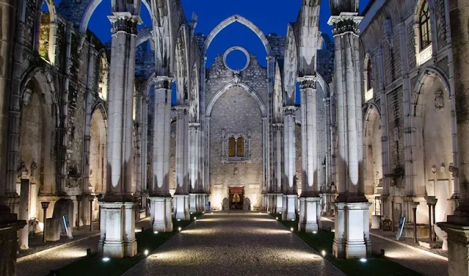
Exact Coordinates / Location
- Latitude/Longitude: $38.7121^\circ\text{ N}, 9.1402^\circ\text{ W}$
- Address: Largo do Carmo, 1200-092 Lisboa
The Best Angle
Walk to the far eastern end of the central roofless nave, directly ahead of the main altar space. Point the camera lens upward at a steep angle using an ultra-wide focal length ($14\text{mm} – 18\text{mm}$). This specific composition frames the high, open-air Gothic arches symmetrically against the sky, letting the raw stone pillars guide the eye vertically through the image grid.
Logistics & Transport
Ride the Metro Blue or Green Lines directly to the “Baixa-Chiado” station and follow the exit signs pointing toward Chiado. From the station exit, complete a flat three-minute walk north along Rua do Carmo into the open square of Largo do Carmo. Admission tickets for adults cost approximately €7.00 for entry into the active archaeological museum site.
Know-Before-You-Go Tip
Because this location lacks a roof, interior lighting is completely dependent on external weather conditions and solar paths. The optimal shooting window occurs between 10:00 and 11:30 when the morning sun rises high enough to illuminate the stone carvings without creating deep shadows. Tripods and large lighting modifiers are strictly prohibited inside the ruins to preserve guest mobility along the stone walkways.
Practical Lisbon Photography Logistics & Equipment Tips
Managing Terrain and Coastal Glare
Lisbon’s urban geography features seven major hills covered in traditional white limestone and black basalt cobblestones, known locally as calçada portuguesa. These stones wear down over decades of foot traffic, becoming slick surfaces that require sturdy footwear with high-traction rubber soles to safely navigate with heavy camera gear. The close proximity to the Tagus River creates a powerful coastal glare that reflects off the white buildings and polished ground stones throughout the middle of the day. Photographers must utilize a high-quality Circular Polarizing Filter (CPL) to effectively cut through these reflections, restore natural color saturation, and protect highlights from overexposure.
Navigating the Public Transit Ticket System
Efficiently moving between distant photographic coordinates requires utilizing the unified public transportation infrastructure. Photographers should purchase a rechargeable Navegante card (formerly known as Viva Viagem) at any automated metro station terminal for a base cost of €0.50.
Loading this card via the “Zapping” method allows users to load a monetary balance that provides discounted single fares across different transport operators, including Carris buses, historic trams, the metro system, and regional trains. Alternatively, purchasing a 24-hour transit pass for €6.80 grants unlimited rides across the metro, public buses, elevators, and historic tram lines, completely bypassing individual ticket queues during a busy shooting day.
Conclusion
Maximizing a photography schedule in Lisbon depends on following a geographical sequence that limits backtracking across steep valleys. Photographers should group locations by district, starting with an early morning run through the Alfama viewpoints before transitioning to the modern architectural lines of Belém in the afternoon. Adhering to the specific tracking coordinates and transport routes detailed in this guide ensures clean, high-utility frames that accurately capture the architectural realities of the city.